Unfortunately, we awoke on the 23rd to the pitter patter sound of a lovely Scottish rain. It became heavier when we hit the road. We became totally drenched within 30 minutes. Cold and somewhat miserable, we pulled into the Kilmelford cafe and store and very sorry to find their cafe was closed on Wednesdays!
Fortune turned when the hotel down the street took pity on us and offered to make us coffee even though they didn't technically open for another hour. We must have looked like near-drowned rats.

We sat next to the fire, drank hot coffee, and later, when they opened, we had a deliciously sizzling order of fish and chips. It had a warm cozy atmosphere and was a needed solace for wet cyclists.

Judging by the color of the ivy, autumn is here. We've felt it change - there's a crispness in the air, and the evening light has a golden cast to it.
After lunch it cleared a bit...

About another dozen miles south we found the Carnassarie Castle.

A formidable place, this was the tower house of John Carswell, the first Protestant bishop of the Isles, who had support from the Earl of Argyll. Sadly it was destroyed by royalist forces after the failed Rebellion against the Catholic monarchy in 1685 and was never rebuilt.

It was fascinating to wander through the ruins and imagine 17th century life in Scotland. Although in ruins today, the castle was apparently quite stylish and lavishly decorated in its day.

While within the Carnassarie castle grounds, our spirits lifted with the clouds. The lovely sun blessed us for a few moments as we climbed the hillside, and then the 81 stairs to the castle's tower which afforded a wonderful view over the Kilmartin Glen.


Looking out from the top of the tower - we enjoyed a great view of Kilmartin Glen while our rain gear dried.

Then down the stairs!


Above is a photo of a beehive cell replica, which were small homes of monks common in this area many hundreds of years ago.

The Kilmartin church is home to high crosses and fantastic medieval gravestones.

The famed Kilmartin high cross was moved indoors for protection from the famed Scottish elements. A beautiful cross, it is thought to be over 1000 years old.

Within the churchyard are many gravslabs from the 1200-1700's.


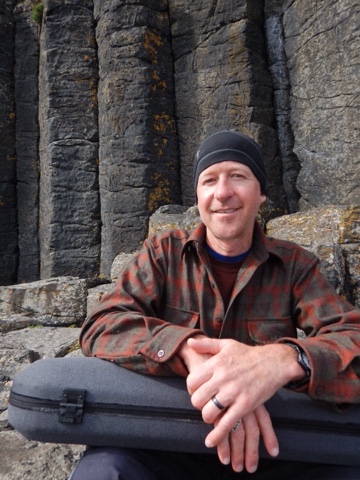
A touring cyclist in his armor, contemplating an ancient stone soldier in his armor...

The sun setting behind the church and graveyard made a very beautiful end to the day.

The kind people at the Kilmartin hotel gave us permission to camp across the street in the large green. Equipped with a picnic table, and public toilets across the street- we were living in luxury! Well, except for the recurrent rain, which drove us to cook, and eat, UNDER the table!!!

Then to the bar at the hotel for a pint and to stay dry and warm, and later to bed. It rained most of the night, of course!

The next morning, a stunning rainbow over the graveyard.
We visited the Kilmartin museum which had an impressive display regarding the area's astounding history. We were amazed to learn that within a 6 mile radius of the village were at least 350 ancient monuments, including the remains of the fortress of the Scots at Dunadd, 25 standing stones, 100 or so areas of prehistoric rock carvings (including cup and ring markings), and numerous charmbered burial cairns. In ancient times this was a very fertile area, was strategically located, and of great religious significance.

We visited several burial cairns below the village. Together these sites are know as the "linear cemetery", as they stretch out for several miles in a line along the valley. These were burial sites of extremely important and presitagious individuals during Neolithic times.

Single cists like this one above were found buried under the cairn sites during archeological excavation. Generally no human remains were found within the cists, as conditions were so acidic that organic material disintegrated well before these sites were uncovered. A single human tooth was found within this particular cist. Chemical analysis of the cists allowed researchers to map the position of the bodies that had been lying within them.

After excavating this cairn, the Nether Largie North, a concrete stairwell was built to allow visitors to descend and view the cist below. While within its depths the rain began again, so we spent a long time contemplating death and ritual in Neolithic Scotland and thinking ...... well, at least we are dry!!! It was a little creepy down there, but fascinating.

Here's another chambered
Cairn, called Nether Largie South cairn. This one was left open after excavation, and one can climb down in to get a sense of the size and layout. This is an older site, initially used as a burial site for many members the farming community, (vs. a single cist as you saw above). Over 5,500 years ago, these ancient peoples were right here, placing the remains of their clansmen in a sacred ritual... Some thousand years later, the archeolgists believe the site was redesigned and reused for additional burials.

The Nether Largie Standing Stones lie just south of the linear cemetery and are thought to have been built approximately 500 years or so after the cairns. It is fascinating to ponder the role of these stones in the lives of these ancient peoples, and to imagine how their complex belief systems and rituals evolved over time.

These stones are thought to have been erected so that they align with the sun's path on the autumnal equinox. And wouldn't you know, we happen to be here at just that time! Sadly, with the intermittent and at times thick cloud cover, we were unable to verify this first hand.

Here is an example of the cup and ring stone carvings mentioned above. These are mysterious markings- their purpose is unknown. Perhaps they could have had religious significance, represented a secret language or served as a musical instrument? Maybe it was a way of mapping the stars, defining territory or signifying a meeting place? Interesting to contemplate!

Above are the ruins of Dunadd, once the imposing and strongly defended fortress of the Kings of Dalraida (Now known as Argyll). Between 500-1000 AD this was a powerful and dynamic center for trade with the continent, the monks of Iona, as well as the aristocracy of Northumbria. Many a skilled craftsmen lived and worked here, creating metalwork in bronze, silver and gold. In addition to archeology, there survived a written record of the Celtic-speaking Irish aristocracy who lived here. These people were known as the 'Scotti', and as the name implies, their legacy lives on in Scotland.

This marking in stone on the top of the fortress's steep hill resembles a foot and was important in the coronation of the kings of Dalriada.
We could have stayed on for several days. As it was, we only barely scratched the surface of the what this incredible area has to offer. Yet, the Jura music festival beckoned, and so we cycled along the Crinan canal over to Tayvallich to catch the ferry to Craighouse.
Day to day summaries:
September 23: Kilmore to Kilmartin via the A816. Visited lovely hotel in Kilmelford, Carnasserie Castle, Kilmartin museum and church. Camped across from Kilmartin hotel and took refuge at the bar all evening. Total 24.25 miles.
September 24 -Kilmartin to Craighouse, Jura via A816, B8025, and ferry from Tayvallch to Craighouse. Visited the linear cemetery (Glebe Cairn, Nether Largie Cairn), Temple Wood Stone Circle, Dunchrogaig Cairn, Cup and Ring stone, Dunadd Fort. Total 16 miles.